East Fork Chulitna-Mistakes Made & Lessons Learned

18 06 2015

I’m not sure why, but every time we start these trips, we try and avoid getting our feet wet at all costs, knowing full well it’s just a matter of time (and usually sooner than later) that our feet will be soaked. In the first 1/4 mile we ran into a large puddle/pond in the four wheel trail and bushwhacked around it. This was the first (and really only) bushwhack of the first day….Less than 20 minutes later our feet were soaked for the duration of the trip.

After going through bushwhack hell on the last trip using the Hardage Creek Route, we decided to take the northern route this time-we’ve seen great reports of little bushwhacking and decided to give it a try.

Beautiful views of Denali and the Alaska Range. Another amazing, sunny, warm weekend in Alaska.denali view beginning

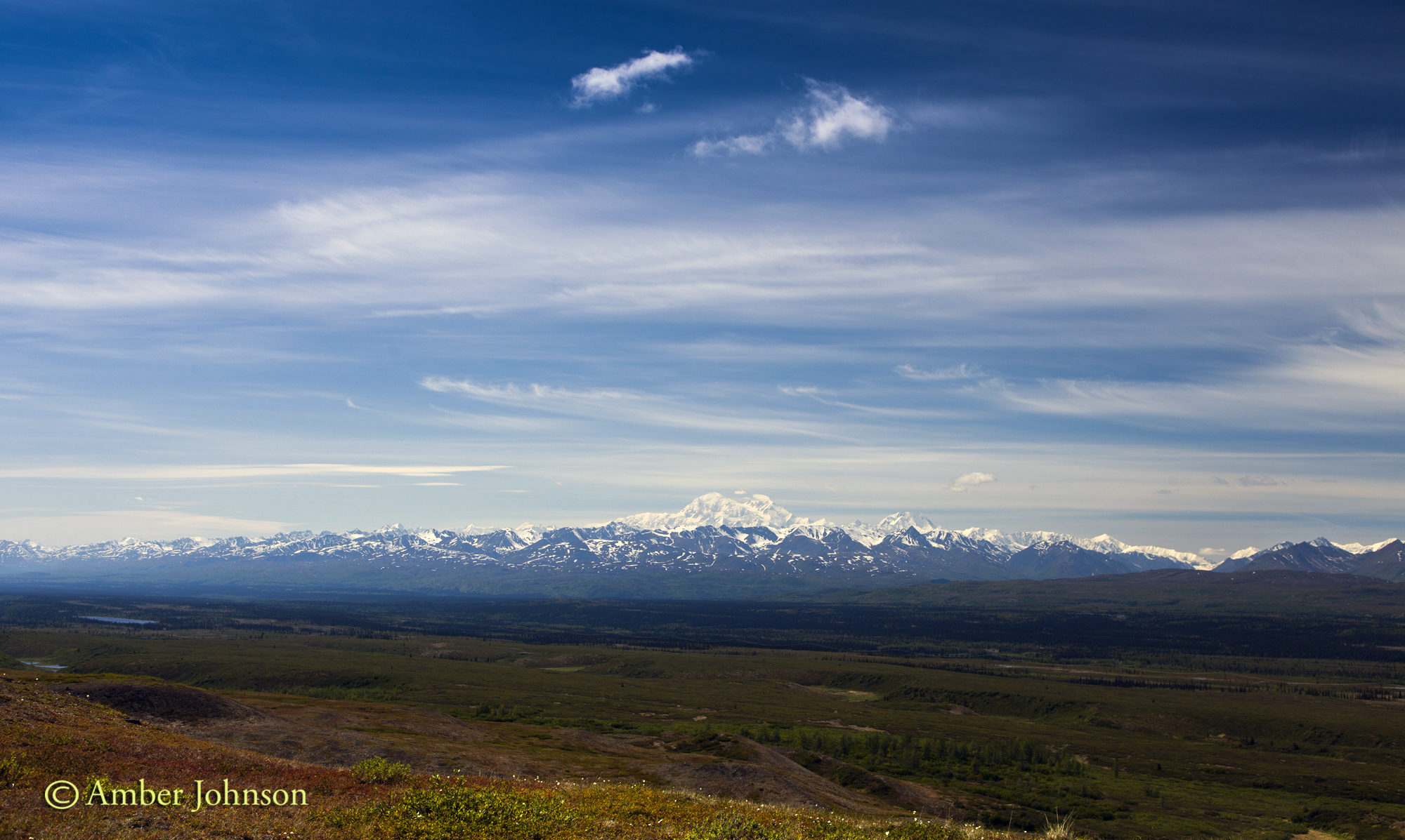
After we left the easiness of the four-wheeler trails, we found some great high alpine game trails.

Boone hiking up towards the pass.

boone hiking

Jeff & Sarah climbing towards the pass.

sarah & jeff hiking

After reaching the pass, we looked at the map. Previous packrafters had taken the ridge left (headed slightly farther upriver), descended towards the creek, then made another pass before getting to the East Fork Chulitna near Crooked Creek. The East Fork Chulitna seemed so close! We decided to roll the dice & try our own route, knowing quite well the odds were greatly against us. Crazy thing is we succeeded 🙂 By doing this, we probably cut 3 miles off the hiking portion of the trip and only sacrificed about 1/2 mile of floating. We decided to stay high, traversing the ridge right.

Boone & Kasey.

 kasey and boone hiking

We started descending the nose & found a good place to take a break and fuel up before what we thought potentially could be a long bushwhack to the river. Here’s the view looking up river to Crooked Creek area. Once we descended to the valley floor, we wound up hiking in the general direction of up river, ending about 1/2 mile below the confluence of Crooked Creek.

checking maps

View down river & faintly the Alaska Range.

 group view of valley

We managed to find a route down, all tundra hiking. From the top we scouted several treeless areas & headed towards the first one. We easily linked up open areas with animal trails through the trees. It was definitely not a bushwhack. We even found a large downed tree to cross the creek on.

Sarah heading down the nose.

   sarah hiking down

Camp! I love Alaskan summers! I took this at 10:30 pm.

camp

Our put-in to the East Fork Chulitna.

yak

The first few miles of the paddle went smoothly. Fun, Class 2. Splashy. I’ve done this paddle before and loved it. The two canyons were challenging and the rest was pure easy fun. I led the paddle into the first canyon-a Class 3/3+ canyon. After making the first few rapids, I made a costly mistake-I got to close to a boulder, got high sided, from which I couldn’t recover and went for the swim of my life. I’m not sure if it was complacency  or just the littlest/giant mistake. Going into that rapid, I thought I had it. There wasn’t even a question in my mind. Now, instantly, I knew I was in pretty big trouble. There are few small eddies in the canyon, mostly rock walls, and I had 3 big drops to go & probably 125 yards till the river calmed back down to a fast Class 2.

I managed to hang on to my raft and my paddle, trying desperately to right my raft & when eddies appeared swimming desperately for them. I was almost able to catch one or two before the current grabbed me & threw me into another rapid. I was being thrown into boulders & over drops, getting pushed underwater, then being able to come up for air in time for the next one. My crew was desperately trying to catch me & help, doing everything possible. At one point, Kasey got to me, but I was unable to get close enough to her to grab her boat before we got separated in a rapid. Finally, my boat got caught on a large boulder (upside down) in an impossible place in the river. Boone caught up with me at some point & I was able to grab onto him for a second before we came upon the next rapid and had to let go. I was absolutely exhausted and knew I had to keep fighting. I kept swimming with my paddle, the river tossing me around like Raggedy Ann, with my head headed straight into a boulder. I narrowly missed bashing in my skull (how I don’t know, I was suprised-Boone saw it and was trying to figure out how he was going to get me unconscious or dead out of the river.) Regretfully, I had left my helmet at home. Definitely, won’t be doing that on future trips. Finally, I dumped out of the canyon into Class 2. The river isn’t terribly deep here-knee to mid thigh-just super fast. Boone managed to get to me, with Jeff right behind him. I grabbed onto the rope on the rear of his boat and he managed (I don’t know how) to get us to shore-NOT in an eddy (He said it was like dragging 3 boats). He jumped out of his boat, grabbed me with one hand & his boat with the other hand. I was so exhausted I couldn’t walk. I laid on shore breathing hard & exhausted-happy to be alive.

My hands were frozen-screaming barfie style, but the rest of me was relatively warm & dry. I felt like I had been through Fight Club-exhausted, my legs were so beat up-deeply bruised muscles, with visible ones on the surface (some bigger than my hand), as well as some good gashes. But I was ok. I did get a hole in my brand new Stowaway Tough drysuit by Alpacka-although, I truly believe this would have happened in my regular Kokatat drysuit as well. My long underwear was also ripped and I had a gash in my knee where the drysuit was ripped. I stayed pretty dry despite the hole. In the end, my pack broke the Packtach rope in half from the water pressure & floated downstream. Boone was able to jump in his boat & grab it. The pack coming off knocked the boat off the boulder into an eddy. Kasey & Sarah had managed to eddy out and grab it. Also, it happened to be one of the fewer parts of the canyon they could hike out of-so they packed up everything & hiked out to us.  I was so happy to see them.

Since I was to exhausted to boat the second canyon, (and the big class 3/4) rap, we had to hike around it (maybe 1 or 1 1/2 miles). I mean bushwhack. It was the hardest hike ever due to my legs being completely sore & beat up. My muscles barely wanted to put one foot in front of the other, much less with a pack & climbing over hills.  Thankfully, my crew grabbed my boat, paddle & pfd to take some weight off my back. Sometime after the big rapid, we managed to hike down to the river & paddle the rest of the trip. The rest of the float is a fun, splashy Class 2 all the way back to the highway. Although, I tried to enjoy the rest of the paddle, and definitely had some good moments, it just wasn’t the same for me. We got back to the car a few hours later than we expected due to the swim, and ended up getting “stuck” in Talkeetna, due to the Sockeye fire in Willow. It was 80F and a good place to chill out, relax, & reflect over a few beers on the banks of the Talkeetna River with the sun setting over Denali.
sunset denali talkeetna


Early Season Skiing at the Jewel

24 10 2012

With blue skies and fresh snow, we decided to ski the Jewel Glacier (an early season gem) along with every other backcountry skier in Southcentral. Holy smokes it was crowded! I would’ve thought the 3.5 mile approach would’ve detered a few peeps….but not so much.

View of the Milk Glacier. Boone ditched us in the parking lot to ski the Milk, and on the lower right of the glacier, you can barely see Boone and his friends skinning up. They made the right decision to avoid the crowds and ski the Milk, they had it all to themselves.

  Boone & his friends skinning up the Milk.

View of Crow Pass and Crystal Lake. Rumor has it 12 people stayed in the cabin at the lake the night before. We saw a bunch more people headed in with big packs on our way out…..glad we did this as a day trip.

Kasey enjoying the fresh pow.

Ryan dropping in on a good line.

Kasey dropping a knee.

Kasey and Ryan headed back on the Crow Pass trail.


Summer skiing in AK…..

24 08 2012

Skiing Tincan in mid-July….still enjoying the epic winter we had! The best summer skiing ever.

Dan testing his mad slush cup skills. Yes, I got drenched taking this photo 🙂

Kasey, Dan, & Boone headed up to the Jewel Glacier on a warm August evening. Best (& longest) August ski!

The clouds rolled in over the glacier and created some interesting visibility.

The clouds were moving quickly. One moment white out, the next glimpses of the surrounding peaks.

Joel came to town from Australia and wanted some turns, so we I headed back to the Jewel. Found these four mountain goats right off the trail.

Joel checking out a waterfall off the end of the glacier.

70 months skiing and counting!


The Shrode Lake Cabin/Skiing in Prince William Sound

1 05 2012

We are probably the only people to drop a keg into a glide crack 🙂 No worries, it was definitely rescued! The fact that we were bringing three, five gallon kegs (of some of Midnight Sun’s finest), hardly made the fact the that I brought two sets of boxing gloves seem excessive.

Mike, Michelle, and Parker on the boat ride in.

We got dropped off on a beautiful, sunny perfect day in the Sound. I love PWS on a flat calm day! We lucked out and saw a young humpback whale on the way. We arrived at the put-in (we got dropped off before Three Fingers Cove because it was iced in) to an enormous amount of snow!

The snow towers over Michelle.  Jon (at 6′ 5″) was just able to touch the top of the snowbank from the beach. We’ve had an amazing winter in AK!

Jon and Dan on the ski in. Probably wouldn’t recommend heavy, overloaded sleds. We had an interesting tour in, to say the least, over the hilly terrain. It took us about 4 hours to get to the cabin, what should take an hour-ish. At least we made sure we were properly hydrated first 🙂

This butterfly kept landing on my skis. Again with the overpacking, I brought xc skis and my AT set-up.

It was hot outside! I’m glad I threw in a tank top and shorts at the last minute. We decided to go for a ski after we dropped our stuff of at the cabin. Boone with Shrode Lake on the right and PWS on the left.

Boone and Michelle checking out options.

Michelle and Mike descending down towards Shrode Lake.

We were told that the people that had the cabin the weekend prior found only the top 18 inches of the hut peaking through the snow. Luckily for us, they dug a burrow down into it.

Czech Yourself and Mammoth Stout-mmmm!

The suprise entertainment I brought-boxing gloves!

 Mike skiing above Jack Lake. The conditions were less than stellar. It had rained for the day and a half prior -what a surprise in PWS :), and the snow was saturated. We pointed our skis and barely moved. It felt like skiing with our skins on. But the tour was gorgeous…..

Mike and Michelle touring back across Jack Lake.

Michelle, Mike, and Parker found the perfect way to relax in the evening sun.

Our last day, Dan and I decided to get one last ski after we dropped our gear off at the pick up beach. It turned out to be pretty decent spring corn/slush.

Jon doing his share to lighten the load 🙂 Another glass calm day in PWS.

Michelle and Mike waiting at the pick up beach in style!


R.I.P. the Lane Glacier

13 10 2011

The Lane glacier is dead. Well, almost. We headed up there last weekend for some early season fresh pow (it used to be THE place to go ski in September.) We figured, certainly a week into October there should be something decent.

Dan, Parker, Cosmo, Chad, and Jon on the hike in.

What we found was the Fast and Slow Lanes no longer connect. The Fast Lane is very short. The boulder field to get there always sucked, now it seems 4x as long as the glacier has receded, and you have to travel up the valley a lot farther to reach skinable/skiable terrain.

A look back partway up the talus field. We used to be able to skin through this area.

Hiking over boulders with 4 inches of snow is always a little challenging-although it’s better than the last time I went 3 years ago and there was 8 inches….although then you could ski all the way down to the boulder field above the Lane hut.

More boulders. Chad and Boone negotiating the endless field of talus with the Fast Lane above them.

We checked out the Fast Lane first. We didn’t end up skiing it-the measly four inches of snow was not bonded at all to the glare ice underneath. Boone, Chad, and Cosmo hiked up and over, meeting the rest of us at the Slow Lane. Dan and I decided not to join them when we saw Cosmo lose his footing and slide halfway down the icefield.

Boone hiking up the Fast Lane.

Chad on the Slow Lane.

Boone.

Boone skiing what he called “loud powder”- four inches of snow on top of glare ice.

Our tracks on what’s left of the Slow Lane.

Boone, Chad, and Cosmo on the trek out.


The Brooks Range Trip: Part 3-Arrigetch Creek to Takahula Lake

26 08 2011

We got back on the Alatna River on day seven, the same day we came out of the Arrigetch. We were welcomed by sunshine and warm temps! It was great to dry our gear out after a few soggy days in the mountains. We decided to put in a few miles before making camp for the night. Luckily, that night we saw a family of wolves! Unfortunately, I didn’t get a pic, but we caught glimpses of a full size adult silver colored wolf, and a good look at a wolf pup/adolescent in and out of the brush along the riverbank. Definitely a highlight of the trip!

The Alatna River widens quite a bit right before Arrigetch Creek into a faster flowing Class 1. At one point, Boone clocked us on his GPS  at moving 6.7 mph, and I wouldn’t be suprised if in a few areas we moved a little faster. With all the rain that the lower river had received it was muddy, and running high.

Kasey doing the worm on our last beach we camped at.

Kasey tending the fire.

Fall colors were just starting to appear.

The last morning, Day 8, started out with high clouds, quickly breaking to warm sunshine.

Boone and Dan headed down river.

Kasey.

Kasey and Dan in the sun!

The take out from the Alatna river. Like most mud/sand we found along the river it had bear tracks. Throughout our time on the Alatna it seemed that most beaches/mudbars had bear, wolf, and a few caribou tracks. From here we had a short portage to Takahula Lake, then a paddle across the lake to the pick-up beach.

Kasey and Boone on the beautiful Takahula Lake.

Takahula Lake! The sea green water looks like the Carribean! We couldn’t help ourselves. We swam. It was less warm than the Carribean 🙂


The Brooks Range Trip: Part 2-The Arrigetch Peaks

22 08 2011

We ditched our packrafts and extras down at Arrigetch Creek, and headed up into the mountains for the ten mile hike to the Arrigetch Peaks. The Arrigetch remind me of Hatcher’s Pass on steriods. Huge granite spires, with mounds of boulders & blueberries lining the valley floor it is a climber’s and hiker’s paradise.  The name Arrigetch comes from the Inupiat language meaning “fingers of the outstretched hand.”

Our first good glimpse of the Arrigetch with Arrigetch creek flowing out.

We lucked out and had hot, sunny weather for the hike in.

We made the mistake of not looking for the bear trail that follows the creek up and went high instead, bushwhacking through alders and tussocks for two hours. We then dropped down towards the creek and found the much easier bear trail. It’s 100% worth it to locate this trail sooner than later. We took a leisurely 7 hours to do the hike, stopping for snacks and pictures along the way. It could easily be done in 5-6 hours if the bear trail is found early on and not so many breaks [not the 12 hours we were assured it would take as the portly ranger in Bettles told us 🙂 ]

The Maidens.

Kasey and Boone at one of many creek crossings. Dry feet are not an option.

Kasey’s and my tent up in the Arrigetch. It leaked like a sieve, we would find out in the next two days of pouring rain. We ended up having to sleep with dry bags on top of our down sleeping bags to prevent the rain hitting soaking them (thus rendering them useless) and packing up everything into dry bags while we were gone from the tent.

I’m not sure what these bright pink plants are. They resembled blueberry bushes, but pink and no berries. I found a whole field of these cool plants. As for blueberries, there were tons throughout the Alatna valley and in the Arrigetch. We enjoyed grazing, and they made delicious additions to our oatmeal in the morning.

Boone and Dan scouting out our hike up Mt. Ariel the next day.

The next morning we got shut down on a summit. It was nice at our tents, for a little while.

The rain quickly moved down valley, making talus fields treacherous. Eventually, the whole valley was socked in and the peaks were all hidden from view.

The next day we thought we had a chance. There was actually some blue sky directly overhead.

We got shut down again by rain and the low clouds that moved in. We ended up hiking up to this bench over lots of slippery talus to catch a glimpse of some glaciers for a brief moment.

Looking back down the valley to the low lying clouds.

The rock was covered with brilliant orange lichen.

Interestingly, on the whole hike/packraft from the headwaters of the Alatna to Takahula lake the only time we ran into other people was in the Arrigetch. We met two different groups there, one group of two people doing a similar trip as us. The other group had been there a week, went up in the mountains on the one nice day, and got shut down the rest of time, not being able to make the mountain pass they had hoped for, ending up in the same place as they began.  The Arrigetch Peaks were amazing to see, even though we got shut down from any summits or climbing.

The fourth day in the Arrigetch we woke to sunshine on our tents and down valley, but again, the mountains up from our tent had low lying clouds and rain. We packed it up, and headed back for our boats to continue the rest of our adventure to Takahula Lake.


The Brooks Range Trip: Part 1-Geadake Lake to Arrigetch Creek on the Alatna River

19 08 2011

The only words to describe the Brooks Range and Alatna River are amazing and stunningly beautiful. The Alatna is one of six designated Wild and Scenic Rivers in Gates of the Arctic National Park, and for good reason. The Endicott mountains range from rolling hills to sharp, jagged spears and everything in between. Many are reminiscent of the southern Rockies-very unlike any other mountains in Alaska.

Dan, Boone, Kasey and I got dropped off by floatplane in bright, late afternoon sunshine (after flying through rain the whole way) on Geadake Lake, the headwaters of the Alatna, where the Alatna River starts as a trickle flowing from the southern end of the lake.

Immediately, we found a caribou rack & skull-the first of a few we came across!

Fresh snow dusted the peaks 1,000 feet up. Being the second week of August, temperatures ranged from below freezing to upper 50’s or low 60’s, and the weather jetted in and out so quickly it was hard to keep track of. During our 8 day trip we lucked out and only had 2 solid days of rain, one or two days or rain/sun, and the rest was mostly sunny.

From the lake, we hiked through tussocks for 3.5-4 miles before the river was big enough to launch our Alpacka rafts.

Along the way we were treated to caribou dancing across the tundra.

We found snow on the river bank……

Early in the afternoon, on our first river day, my boat started losing air. We found the main valve to be seperating from the raft. We had to stop every 5-10 minutes to re-inflate the boat. We set up camp early that day so we could fix my raft with Aquaseal, before we were to hit the rapids above Ram Creek. Luckily, it held. Also, the river looked like it was at an average flow, and the rapids ended up being an easy Class 2 (not the 2+/3 that the river guide suggests, maybe at a different water level they are.) The rest of the river is Class 1.

Fresh wolf tracks! We found loads and loads of wolf & bear tracks on every sandbar. These tracks are from a wolf that came through our camp overnight.

Boone leading the pack.

Kasey heading down river.

The crew.

Dan.

Rain down river. The weather moved with lightning speed up and down valley.

A short time later, blue skies.

Boone cooking dinner on a backwater channel of the Alatna, near Arrigetch Creek.

This night it dipped below freezing, and we woke up to frosty sleeping bags and some ice on the channel. From here we stashed our boats, and headed into the Arrigetch Peaks for the second part of our trip.

 To be continued………..


Packrafting Curry to Clear Creek

22 06 2011

Curry to Clear Creek is an amazing combination of backpacking, bushwhacking, packrafting, and a train ride! It’s approximately a 14 mile hike from where the train drops you off, part on an ATV trail, part high tundra hiking, and loads of bushwhacking. Once you reach Clear Creek it’s a 15 mile paddle back to Talkeetna (10 miles of fun, splashy class II/III on Clear Creek through rock gardens and wave trains, then 5 miles of pure slacker easiness on the Talkeetna River).

We lucked out with blue skies and temps in the 70’s, which was on the sweltering side for this Alaskan girl (I don’t know how I ever survived going to school in the desert).

View of Denali from the train.

Dan and Boone in Curry.

Let’s just say there is a few bears in the area. We only saw one……

The Alaska Range with Denali peaking through the clouds on the left.

Caribou!

One of the easier bushwhacks. Most were in 6-8 foot dense alders.

Dan taking a break in the sun.

Our shadows at 11 pm on the tundra.

Boone taking a nap at Clear Creek.

Dan and Boone headed down a small rapid.

***I did this trip again in July of 2012. We saw a note on the packraft.org website that there was a trail under the powerline. We decided to try and find it-it was well worth it! Take the 4 wheeler trail all the way to the powerline. It’s a game trail and from a distance, definitely doesn’t look like it exists through the alders, but it saved us 2-3 hours at least (not to mention, lots of scratches and bruises from the bushwhack.) A few times it fades in the small ravines, but always picks up on the other side. Follow the powerline to the high tundra, camp, then make a bushwhack descent…..*****


Skiing the Jewel

12 10 2010

Saturday Boone, Dan, and I headed to Girdwood to ski the Jewel Glacier.  We started our 10 mile, 3500 ft elevation gain (after 3 laps) in the clouds, which quickly gave way to sunshine!

View from the Jewel. Crystal Lake and Crow Pass.

Boone booting up towards the Jewel.

Dan booting up with a view towards Girdwood.

Looking back towards Crystal Lake and Crow Pass.


View of the Milk Glacier.

Dan skiing down the Jewel Glacier.

We decided to head towards the Raven Glacier, but the Havocs got worked on some rocks below the Jewel. It’s still early season 🙂

Boone climbing back from the aborted attempt at skiing the Raven.

Boone descending towards Crow Pass.